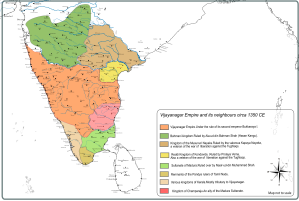
This map is a small demo of what can be done with the blank template map that was traced out as part of the Historical Map of India project.
The political situation in South India and greater part of Maharashtra during 1350 CE has been shown on the map.It still needs a lot of work regaridng correction of boundaries,showing smaller principalities,correction of place names etc etc.But to visualise what the political topography of South India was in the middle of the 14th century this will be useful aid.
This is only one of a series of maps.It can be used to depict battles,movement of troops etc.
Comments and feedback welcome.


very good chunk of information , looking more for this kind
Comment by saurabh singh — December 8, 2012 @ 2:55 pm |
Really nice It is very helpful.
Comment by Shaik Hussain — January 9, 2015 @ 7:47 am |
great work
Comment by Venkata Sairam Neeli — January 23, 2016 @ 6:58 am |